For years, scientists have been warning us about the state of our coral reefs. Now they’ve created a map that could help us save them!
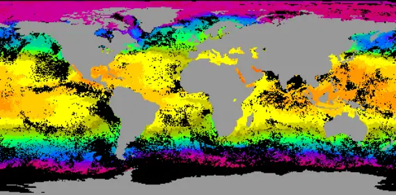
The Allen Coral Atlas is an innovative tool for policy makers and conservationists alike, as it provides detailed information on over 50% more reefs than were previously surveyed, making this data available to all who need it.
The atlas is the product of three years’ work, more than 450 research teams and nearly two million satellite images.
It was named for late Microsoft cofounder Paul Allen–a philanthropist who had been a catalyst for this project from its inception decades ago.
Accessible by just about anyone with an Internet connection, the Allen Coral Atlas provides high-resolution satellite imagery that is provided and regularly updated by Planet.
Images are cleaned up by Arizona State University and the University of Queensland uses machine learning and regional data to generate different map layers.
The National Geographic Society rains conservationists on how best to use the map, while Allen’s company Vulcan founded the website.

“One of the things that the Atlas represents is a kind of digital public good,” said Andrew Zolli, vice president of sustainability and global impact at Planet.
Previously, only 25 percent of the world’s reefs had been mapped using high-resolution images, and there was no consistent mapping process linking the different regions according to a report from EcoWatch.
“It’s quite an undertaking that hadn’t been achieved at this resolution and with this kind of detail,” director of ASU’s Center for Global Discovery and Conservation Science Greg Asner said during the press conference.
The only limit on the project is depth, as current satellite technology can only “punch through the seawater” to about 49 feet.
The corals are mapped from the Global Airborne Observatory, an aircraft outfitted with advanced measuring instruments utilized from the sky.
The Atlas also includes a bleaching monitoring system that is updated every few weeks to tell users when a reef or part of a reef may be suffering a bleaching event.
This is what happens when warm water forces coral to expel he algae that gives them nutrients and color. This monitoring system enables conservationists to see what parts of a reef might be susceptible to bleach so as not to attempt to plant new corals there.
How to Use the New Coral Mapping System

If you’d like to try out the new coral mapping tool for yourself, visit the project’s website here.
Atlas users can zoom in marine protected areas, satellite reef imagery, and much more.
The project offers one digital map for the Eastern Tropical Pacific (Florida, the Caribbean, etc.), and another part for the South Central Pacific, which includes the Great Barrier Reef.